
The Ultimate Guide to Getting a Property Survey for Homeowners in Ontario

Ilya Tkachov
Updated
If you are applying for a building permit in Ontario, the municipality may ask for a property survey, site plan, plot plan, or drawing that shows your property boundaries and setbacks. That request can feel expensive fast. Many homeowners assume they need to pay $400 to $600 for an old survey, or even thousands of dollars for a new Ontario Land Surveyor report.
Do not start there.
For many homeowners, the cheapest path is to find an existing survey first. It may already be in your closing package, available from your closing lawyer or lender, on file with your municipality, or replaceable for permit purposes with a lower-cost plan from OnLand. This guide walks through the practical order to try so you can get what you need without breaking the bank.
What is a property survey in Ontario?
A property survey is a dimensioned plan of a property. In residential permit conversations, homeowners are often looking for a Surveyor's Real Property Report, or SRPR. An SRPR is typically the survey drawing that shows the property boundaries and the major things built on the lot.
A property survey or SRPR may show:
- Lot size
- Rights-of-way
- Possible easements
- Buildings
- Garages
- Major improvements
- Other property improvements
This is why municipalities like surveys for permit review. If you are building a deck, shed, porch, garage, addition, pool, driveway, or other exterior project, the reviewer needs to know where the legal property boundaries are and whether the proposed work respects required setbacks.
The cheapest way to get a property survey in Ontario
Use this order before paying for a new survey or an expensive historical copy.
1. Check your closing documents
Start with the documents from when you bought the property. Your survey is often already there. Look through the closing package, title insurance documents, mortgage documents, and any attachments your real estate lawyer sent.
Search file names and email attachments for words like:
- survey
- SRPR
- site plan
- plot plan
- plan of survey
- real property report
If you find a survey, save a clean copy and keep the original unchanged. For permit drawings, you can usually draw proposed work on a copy.
2. Contact your closing agent, lawyer, lender, or mortgage company
If you cannot find the survey, ask the people involved in your purchase. Start with your closing lawyer or closing agent. You can also ask your real estate agent, lender, mortgage broker, title insurer, or mortgage company.
Be polite and specific. Ask whether they have a copy of the property survey, SRPR, or plan of survey from your purchase file.
People who work with real estate and buildings often have access to document systems where existing surveys can be found or purchased at a large discount. That may cost you nothing if they already have it in the file. This is usually much cheaper than buying the same old survey yourself.
3. Request the survey from your municipality
If the purchase file does not produce a survey, ask your municipality for building records for your address. The building department may have a survey on file from a past permit application.
Start with routine disclosure if your municipality offers it. Routine disclosure is usually the faster, simpler path for records that municipalities commonly release without a formal freedom-of-information process.
If routine disclosure does not work, make a formal request under MFIPPA, Ontario's municipal freedom-of-information law. Each municipality in Ontario has an MFIPPA process to request documents.
You can use this template when you email or submit the request:
Hello Clerk's Office,

I would like to submit a Freedom of Information request for records related to the following property:

[Street address]
[City], ON [Postal code]

I am requesting copies of any existing surveys and/or site plans.

I am the property owner. Please process this as a general access request under the Municipal Freedom of Information and Protection of Privacy Act, subject to any applicable exemptions.

Please let me know how I can pay the required application fee and whether any additional information is needed to process the request.
If a staff member says the record cannot be released because of copyright, ask for the formal MFIPPA process and a written decision rather than treating that as the final answer. MFIPPA has formal exemptions and appeal rights, but an informal copyright response should not be the end of the conversation if the municipality has the survey on file.
4. Find out if a Registered Plan of Subdivision or Reference Plan will work
This is the step many homeowners miss.
For some permit applications, the municipality mainly needs to verify your legal boundary and setbacks. If your project is simple and your municipality accepts it, a Registered Plan of Subdivision or Reference Plan from OnLand may be enough to establish the property boundary for the drawing.
This can be much cheaper than buying an old SRPR. At the time of writing on July 3, 2026, homeowners often see small OnLand fees for plan-related documents, sometimes around $15 depending on the document and checkout flow. Check the current fee before buying.
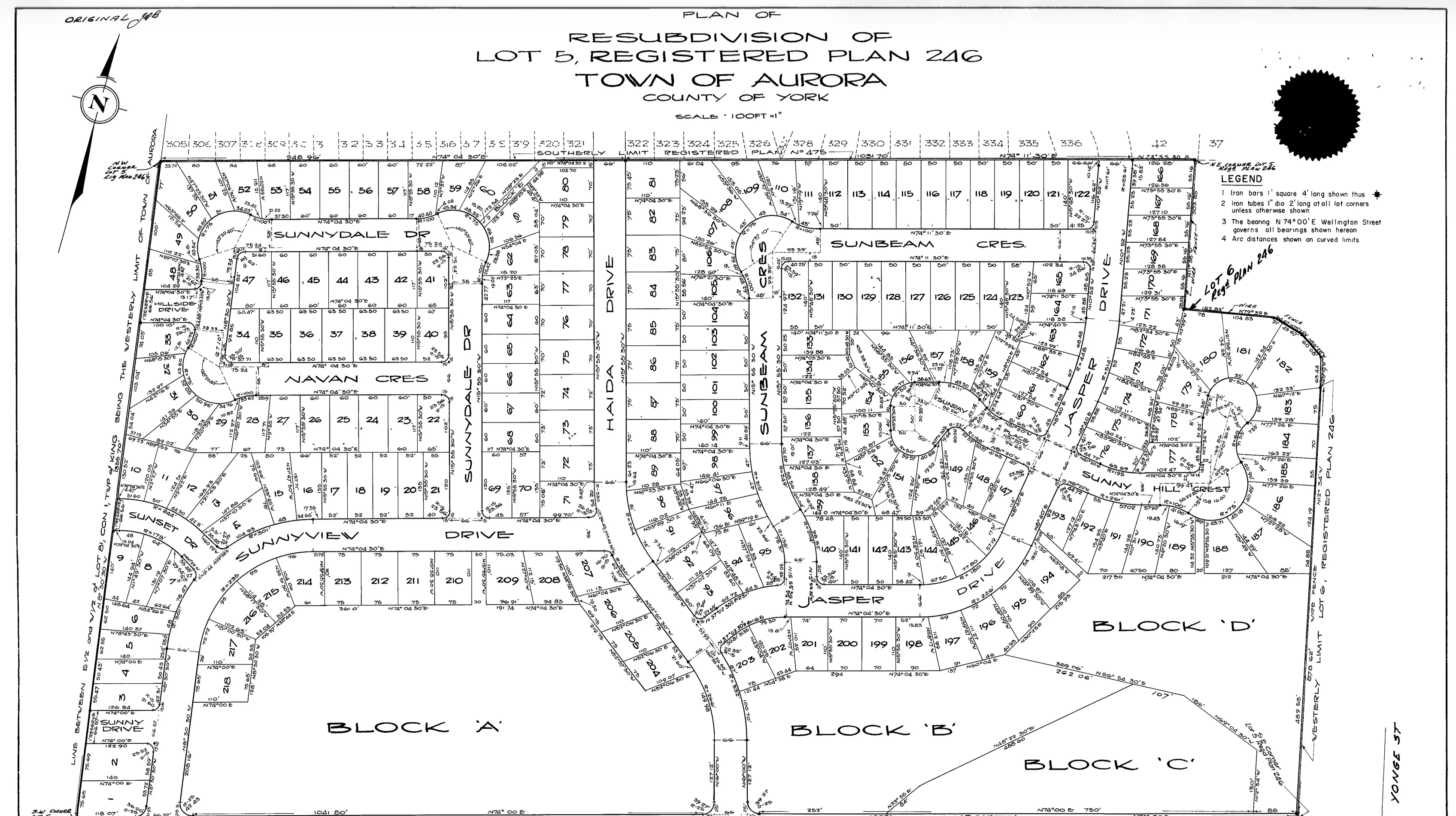
A Registered Plan of Subdivision usually shows the wider neighbourhood, with lots, roads, blocks, dimensions, and survey bars:
 Example registered plan of subdivision showing a neighbourhood layout with lots, roads, blocks, dimensions, and survey bars
A Reference Plan is usually more zoomed in and identifies specific parts of a lot:
 Example reference plan showing parts of a lot, boundary dimensions, survey monumentation, and a surveyor's certificate
Ask the building department a direct question:
Will you accept a Registered Plan of Subdivision or Reference Plan for my permit if it shows the legal property boundary and I mark the proposed work and setbacks on my site plan?
For many basic projects, the key issue is whether you are legally allowed to build where you want to build. The reviewer needs enough boundary information to check setbacks. A plan that marks the legal boundary may solve that problem even if it is not a full SRPR.
See the section below on how to get a Registered Plan of Subdivision or Reference Plan from OnLand.
5. Use ProtectYourBoundaries
If the survey is not in your closing documents, your purchase team cannot get it, the municipality does not have it, and an OnLand plan will not work for your permit, then look at ProtectYourBoundaries.
Use this as the last step, not the first. You may be able to buy an existing historical SRPR there, but it can be expensive. SRPR's typically cost $500-$600 here, but the benefit is you get instant access.
6. Hire a surveyor
If no existing survey is available, you may need to hire an Ontario Land Surveyor for a new survey, which is a different cost and timeline.
In Ontario, we have a shortage of surveyors and high demand, meaning prices to get your property surveyed are high. Costs can range from $2,000-$6,000 CAD, and it can take weeks to get your SRPR.
What is actually available on OnLand?
OnLand is Ontario's online access point for land registration records. Its Property Search lets users search by PIN, address, instrument, or map and order items such as a Parcel Register. Its Documents Search lets users order copies of instruments, plans, and evidence, and search plan indexes.
OnLand is useful, but it is not the same thing as a municipal building file or a private survey database. It does not contain Surveyor's Real Property Report, or SRPR.
Parcel Register
A Parcel Register is the title record for a property. It can help you find ownership, legal description, registered instruments, and references to documents affecting the property.
If you are trying to understand easements or rights-of-way, start with the Parcel Register. Easements are documented on a property's Parcel Register and related registered instruments, which can be purchased through OnLand Property Search.
You can find this data without having to purchase an expensive survey. A parcel register is fairly cheap, ranging from $5-$15.
Instruments
Instruments are registered documents affecting the property. They can include transfers, mortgages, easements, restrictions, agreements, and other registered items.
If the Parcel Register lists an easement or right-of-way instrument, you may need to order that instrument to understand the details.
Registered Plans of Subdivision
Registered Plans of Subdivision are plans approved under the Planning Act that create lots that conform with zoning. Modern subdivision plans will usually show lot dimensions and survey monumentation, such as survey bars.
They usually do not show buildings, garages, decks, sheds, pools, driveways, or other improvements on the property.
Here is an example of what one looks like. Notice how it shows the whole neighbourhood with lots, roads, blocks, dimensions, and survey bars.
Example registered plan of subdivision showing a neighbourhood layout with lots, roads, blocks, dimensions, and survey bars
Reference Plans
Reference Plans are plans of survey that are deposited in the Land Registry Office. They are used to show parcels of land or parts. The parts may or may not represent whole lots.
Like plans of subdivision, Reference Plans show property dimensions and survey monumentation. They may show the location of fences in relation to boundaries, but they usually do not show buildings or other improvements on the property.
Here is an example of a Reference Plan. Notice how it is more zoomed in than a subdivision plan and identifies specific parts of a lot.
Example reference plan showing parts of a lot, boundary dimensions, survey monumentation, and a surveyor's certificate
SRPRs are not stored on OnLand
A common Ontario misconception is that you can simply search OnLand and download your SRPR from the Ontario Land Registry Office. In most cases, that is not how it works.
An SRPR is usually a surveyor's report prepared for a homeowner, lender, lawyer, builder, or transaction. It is commonly found in closing documents, real estate files, municipal permit files, or survey databases. It is generally not the same as a registered plan, subdivision plan, reference plan, Parcel Register, or instrument from OnLand.
That is why the best path is:
- Closing file
- Closing professionals and lender
- Municipality
- OnLand plan alternatives
- Historical survey purchase or new survey
Can a subdivision plan or reference plan be used for a permit?
Sometimes, yes.
For a permit, the municipality often wants to confirm that the proposed work is within the legal property boundary and does not violate setbacks. A Registered Plan of Subdivision or Reference Plan can sometimes provide the boundary dimensions needed to draw a permit site plan.
This is not guaranteed. These plans usually do not show your house, garage, driveway, deck, shed, pool, or other improvements. They may also omit easements and rights-of-way that matter to your project. But if your municipality accepts the plan as boundary support, you may be able to mark your proposed work and setbacks on a site plan without buying a full SRPR first.
Before buying anything, ask the municipality whether it will accept the plan type for your project.
What to ask your municipality
If you are considering an OnLand plan, ask:
For this permit, will the building department accept a Registered Plan of Subdivision or Reference Plan if it shows my legal property boundary and I add the proposed work and setback dimensions?
Keep the email simple. You are not asking for legal advice. You are asking what document the municipality will accept for the permit review.
How to get a Reference Plan or a Registered Plan of Subdivision from OnLand
The OnLand website and terminology is very confusing. We've done the hard work of figuring out how to pull these plans out from OnLand for you. Follow these steps:
1. Search for your city or region
Go to OnLand and search for your city, town, or region. Select the matching Land Registry Office from the results.
 OnLand Land Registry Office search for a city or region
2. Open Property Search
Click Property to search for property information by address, PIN, instrument, or map.
 OnLand Property Search card
3. Search by address
Click the Address tab, enter your street number and street name, fill in the requested-by field, and click Search.
 OnLand Address tab with address fields and search button
4. Read the property details
This is the important step. The property details tell you whether the legal description points to a Registered Plan of Subdivision or a Reference Plan.
Descriptions with LT, LOT, BLK, or BLOCK, followed by a lot or block number and PL or PLAN, usually point to a Registered Plan of Subdivision. In this example, PL 517 is the plan number.
 OnLand property details showing a subdivision plan number
Descriptions with PT, PART, or PTS, followed by a lot or block and a part number on an R-plan, usually point to a Reference Plan. In this example, 38R4146 is the reference plan number.
 OnLand property details showing a reference plan number
A Reference Plan is usually the better document for a homeowner permit drawing because it shows the property in a more zoomed-in view. A subdivision plan usually shows the whole neighbourhood, and the lot number in the legal description points you to your specific lot within that larger plan.
5. Open Document Search
Go back to OnLand and click Documents.
 OnLand Documents search card
6. Open Instruments, Plans and Evidence
Under Document Images, click Instruments, Plans and Evidence.
 OnLand Instruments, Plans and Evidence link
7. Search the registration number
Enter the registration number from the property details and click Search. Remove spaces when you enter the number. For example, search PL517 for a subdivision plan or 38R4146 for a reference plan.
 OnLand registration number search result for a subdivision plan
8. Pay for and download the document
Select the digital download option, pay the fee, and download the plan. A typical digital plan download is around $15.
Quick comparison of survey options
| Option | Best for | Cost expectation | Main limitation |
|---|---|---|---|
| Closing documents | First place to check | Usually free | You may not have the full file anymore |
| Closing lawyer, agent, lender, or title insurer | Finding an existing survey from the purchase | Often free or discounted | They may not have retained it |
| Municipal routine disclosure | Getting a survey from a past permit file | Usually cheaper than buying a survey | Depends on whether the municipality has it |
| MFIPPA request | Escalating when routine disclosure fails | Usually modest request fee plus possible processing fees | Formal timelines and possible exemptions apply |
| OnLand subdivision or reference plan | Boundary support for some permit site plans | Often nominal compared with a survey | Usually does not show buildings or improvements |
| ProtectYourBoundaries | Last-resort historical SRPR search | Often hundreds of dollars | May still not have your survey |
| New Ontario Land Surveyor survey | When no existing option works or exact current survey is required | Usually the most expensive option | Cost and scheduling delays |
Frequently asked questions about getting a property survey in Ontario
Is an OnLand plan the same as a property survey?
No. OnLand can provide registered land records, including Parcel Registers, instruments, subdivision plans, and reference plans. A homeowner SRPR is usually not simply sitting on OnLand as a regular property-search download.
Should I buy a survey from ProtectYourBoundaries first?
Usually no. Check your closing documents, ask your closing lawyer or lender, request municipal records, and confirm whether an OnLand plan will work before paying hundreds of dollars for a historical survey.
Can the municipality refuse to give me the survey?
The accurate answer is that municipalities have formal access rules, exemptions, and appeal processes. Start with routine disclosure because it is faster. If staff will not release the record informally, ask for the MFIPPA process and a written decision. If the municipality has the record and gives an informal copyright-based refusal, do not treat that as the end of the process.
MFIPPA decisions can be appealed, and your case will be put in front of the Information and Privacy Commissioner. An IPC mediator investigates the dispute and tries to help both parties reach an informal, mutually agreeable settlement. This sounds scary, but it isn't - municipalities are frequently asked to provide the documents through these decisions that they have refused to provide initially.
Do I need a brand-new survey for a permit?
Not always. Many residential permit reviews only need enough reliable boundary information to check setbacks. Some municipalities may accept an older survey, a survey from a past permit file, or a site plan based on a Registered Plan of Subdivision or Reference Plan. Others may require a current survey for certain projects. Ask before paying for a new one.
Where do I find easements or rights-of-way?
Start with the Parcel Register on OnLand, then order the related instruments or plans listed on title. A property survey may also show easements or rights-of-way, but the title records are the place to check what is registered.
Can I call local surveyors to get access to my survey?
All surveyors in Ontario share the same database for surveys; they frequently collaborate using each other's surveys. You will be redirected to a place where the surveys are all for sale on ProtectYourBoundaries.
Conclusion
Getting a property survey in Ontario does not have to start with a $600 purchase. Work from the cheapest, most likely sources first: your closing package, your closing professionals, the municipality, and OnLand boundary plans. Only move to paid historical survey databases or a new Ontario Land Surveyor when the lower-cost options cannot solve the permit problem.
